Bugaboo Creek, flowing into the Columbia River
Bugaboos, mountain range
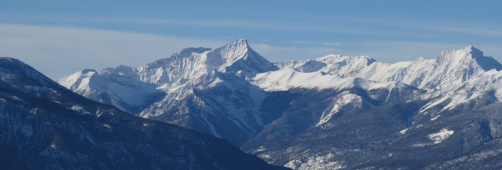
Bugaboo Spire, mountain
Bugaboo Provincial Park
Bugaboos / n / a nemesis; a real or imagined obstacle that cannot be overcome; something that always causes failure or bad luck.
Early Exploration
Bugaboo Creek has its headwaters in the Purcell Mountains, and flows into the Columbia River a short distance from Spillimacheen. According to a some sources, the name “Bugaboo” comes from a mining claim of the same name, however looking at original source material this seems to be a bit of a chicken and egg scenario. The first mention I’ve found of Bugaboo Creek was in September 1890.1 Reference to a Bugaboo Group of claims was not made until some seven years later.2
The first hint of settler exploration up the creek was in 1890, although perhaps as early as 1889, when two well knowing mining prospectors, Archie McMurdo and T Mercier, wandered up to poke around.3 If any mining claim was made at that time it went unnamed in the newspapers or in the official report to the Minister of Mines. That report was no more specific than mentioning that, “good prospects” had been located up Bugaboo Creek.4
Origins of the Name
Given the scarcity of recorded information, and the lack of any mention of Bugaboo Creek before 1890, it seems likely that the name was given by these prospectors as a means to identify the area they were exploring. The origins of the name, therefore, seems entwined with the etymology of the word “bugaboo”.
Bugaboos / n / a nemesis; a real or imagined obstacle that cannot be overcome; something that always causes failure or bad luck.5
The word “bugaboo” was not an uncommon one in the late nineteenth century and even into the mid twentieth century: it even made its way into an 1969 Master’s Thesis examining the use of slang in newspaper articles. Used in a sentence, an editorial might discuss, “the bugaboo … [used] to scare the Canadian voter,” or state that, “The great bugaboo of the birds is the owl… He is a veritable ogre to them.”6 All this to say that calling a creek “Bugaboo” would have invoked a very specific image to settlers at the time.
The Geography
If prospectors up the creek were inspired to name it after something somewhat akin to the bogeyman, their motivations were no doubt tied to the geography of the area. Bugaboo Creek flowed down some 25 miles, in most places through a heavily wooded valley, broken up by a waterfall about 19 miles up, “in itself a miniature Niagara.”7 Eventually, when the forest cleared or if one climbed high enough, there were dramatic views of the glaciers from which the creek was sourced.

Report of the Minister of Mines for the year ending 31 Dec 1898, p 986.
Travelling up Bugaboo Creek, the creek itself split shortly after Bugaboo Falls into the “North Fork” and the “South Fork”. At the head of the North Fork is what has become the classic view of the Bugaboos, with a pinnacle of rock jutting up out of Bugaboo Glacier. Continuing along the South Fork brings one to the head of Bugaboo Creek at Bugaboo Pass.

The Classic View of the Bugaboos at the Head of the North Fork, Sept 1910. Canadian Alpine Journal, 1911, p 33.

The Head of the South Fork, Report to the Minister of Mines for the year ending 31 Dec 1898, p 986.
Development up Bugaboo
Following initial prospecting trips up Bugaboo Creek c.1890, there were occasional rushes to further prospect the area and develop various mining claims. One of the original prospectors, T Mercier, worked hard to cut a trail up Bugaboo Creek in 1896 to his galena ore claim (later the Bugaboo Group), situated on a ridge separating the North and South Forks of the Creek (the ridge off of what is now Frenchman Peak). 8 Further claims were also staked, including the Balrath Group just eight miles or so from Spillimacheen, located by F.W. Aylmer in 1895, and up the East Fork of the Bugaboo (likely Septet Creek) in 1897.9

Now Frenchman Mountain, Report of the Minister of Mines, Eastern District, for the year ended 31 Dec 1936, p 1.
The mining boom up Bugaboo Creek continued from 1897 into the first couple of years of the new century. At the Bugaboo Group, a syndicate under Dr Langis of Vancouver worked to develop a group of claims (the Surprise, Hortense and Magda). At least 100 tons of ore were taken out to ship and cabins were built.10 In 1898 these claims were sold for $63,000 to an English syndicate.11
Another group, the Mercier Group, was located about another two miles along the same ridge on a low saddle at the divide over to the West Kootenay at the head of Bugaboo Creek. These claims (No 21, Western Cross) were sold in 1897 to the Golden and Fort Steele Development Company under Thomas McNaught, and again small ore shipments were planned (galena being the main target, with gold and copper as bonuses).12 A number of tunnels were made, the highest of which was reported at 7,600 feet (2,300 metres) above sea level.
Optimism in 1898 for these two mines (the Bugaboo Group and the Mercier Group) was so great that in 1898 a townsite was reportedly staked below the claims in the basin of the south fork of Bugaboo Creek. This, the “Mercier Townsite” was arranged around a gravel channel with rows of trees on either side, just above a meadow. Although any actual development of the townsite was minimal, it demonstrates the temporary optimism for the mining prospects of the area.13
From Mining to Park
There continued to be sporadic interest in the Bugaboos as a mining location, however excitement never again reached the same levels. The trail up the creek fell into regular disrepair due to fallen timber and washouts. In 1910, the first official survey trip into the area was organized under A.O. Wheeler, who travelled up the creek with the goal of retracing the journey of two prospectors in 1893 who went over the divide and down the Duncan River into the West Kootenay.14
This 1910 trip was the first time the region had been generally surveyed, and although the route over to the West Kootenay never came to anything, the group was impressed by the journey.15 The guide on Wheeler’s trip was so inspired by his first view of the Bugaboos that he would make many return journeys to climb the granite spites. That guide’s name? Conrad Kain.
Wheeler’s survey trip marked the beginning of the Bugaboos being viewed in a new light: this time as a favoured mountaineering destination. In 1965, an initial examination was made in connection to making the Bugaboo area into a major alpine park.16 Five years later, some 61,800 acres was designated as the Bugaboo Alpine Recreation Area, changed shortly after to Bugaboo Glacier Park.17 The Bugaboos, far from a mining mecca, instead became a world class skiing, mountaineering, and climbing destination.
A Changing Park
I grew up with a photo of the Bugaboos on the living room wall, and I made my first trip up to Kain Hut when I was four years old. I’ve returned periodically since then, often enough that I can’t recall a time when I wasn’t aware of the extent of the retreat of the Bugaboo Glaciers. Every time we hiked up to the lookout over the head of the valley, I would compare that view with the photo in our living room and instantly see the difference.
So as a long time visitor, I was quite excited to find a 1911 photo of some of the Bugaboo peaks, and I instantly went through my records to find a photo of a similar angle (mine was taken from a ridge further back, but it’s close). As a mountaineer, I look at that 1911 photo and can’t help but think how much easier it would be to approach the Bugs with that much more snow and ice at the base. I also can’t help but think that once all that snow and ice is gone, the spires will look less dramatic. But all that is merely my opinion: you can judge for yourself.

Snowpatch and Bugaboo Spire, Sept 1910. Canadian Alpine Journal, 1911, p 33.

Bugaboo Range from Chalice Ridge, Oct 2006. Photo: Alex Weller
Footnotes
Other References

Your writings and pictures are wonderful. Thank you for researching and sharing all these.
LikeLike
I’m so glad you’re enjoying them! It’s been an interesting project.
LikeLike
These are the most beautiful photos that I’ve seen of the Bubaboos and they stand alone for their uniqueness! First saw them in the early 1960’s and we climbed to the foot of the Bugaboo Spire. In 1967 we went on a Hans Gmoser Heli skiing trip and how beautiful that was to fly right around the Spires! Will never forget them and Thanks for sharing!
LikeLike
That sounds like an amazing trip! I’m a bit jealous – it’s such a special place, and seeing from the air would be amazing.
LikeLike
Well researched. Great historical content. You may want to research Hans Gmoser , Swiss rock climber , film maker etc, who started taking people into the area in the late 1960’s to ski and climb , thus creating the impetus for heli-skiing , and summer trekking and Spire climbing. Hans used to offer us “Locals” specials back then and several helped him build his first Lodge.
LikeLike
Pingback: Bugaboo Park. – Tokeloshe