Brisco (Community), Brisco Creek, Brisco Range
It seems that Captain Arthur Brisco, in searching for adventure in western British North America, was also in the right place at the right time to have a mountain range named after him.
From 1857 until 1860, the British North American Exploring Expedition, often now referred to as the Palliser Expedition, travelled through western Canada between Lake Superior and over the Rocky Mountains to provide scientific research and information on the landscape, and to report on its potential for settlement and transportation. This is the third in a series of posts about the geographic features named during the Expedition’s travels through the Windermere Valley.
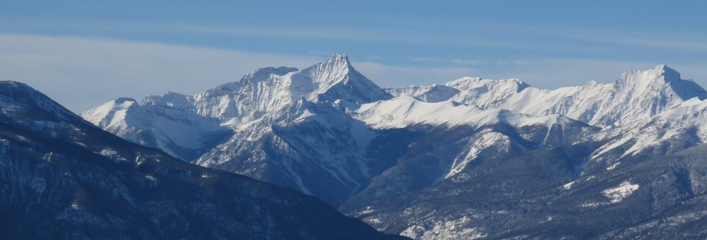
The Brisco Range
The town of Brisco takes its name from the Brisco range, which was itself named in 1858 by James Hector. Hector was a geologist and medical doctor on the Palliser Expedition (1857-1860), a scientific survey of British North America from Lake Superior to the Rocky Mountains.
In 1858, Hector travelled west through Vermillion Pass, followed the Vermillion River down to where it joined with Kootenay River, then looped north up Beaverfoot Creek to Kicking Horse River. Along this journey, Hector made note of the “unbroken wall” of mountains west of the upper Kootenay River and Beaverfoot River.1
Following that season’s travels, on 7 October 1858, Hector arrived at Fort Edmonton where he met two newcomers to the party. A friend of John Palliser’s, Captain Arthur Brisco, along with Brisco’s friend William Rowland Mitchell had come west “in search of adventure and heavy game” and met up with Palliser’s party.2 There is no evidence that Hector was acquainted with the two men before meeting them at Fort Edmonton.
Two days after his arrival at Fort Edmonton, Hector wrote a progress report for the expedition in which he named the mountain range he had seen at the end of August the Brisco Range.3 The identification can also be found on the map made of the expedition’s 1858 travels. It seems that Captain Arthur Brisco, in searching for adventure in western British North America, was also in the right place at the right time to have a geographic feature named after him.

The Brisco Range as labelled on the 1858 map of the routes taken by members of the Palliser Expedition (Hector’s route in blue). John Palliser; John Arrowsmith, British North American Exploration Expedition: country between the Red River settlement and the Rocky Mountains, showing the various routes of the expedition, under the command of Captn John Palliser, 1857 & 1858. Irish Academic Press.
Who Was Arthur Brisco?
Arthur Brisco was born in Hastings, Sussex, England on 16 August 1829 to Wastel and Maria Brisco. The family was wealthy and part of the British Aristocracy. At the age of eighteen, on 10 July 1846, Arthur purchased a commission as a Cornet (now Second Lieutenant) with the 11th Hussars cavalry regiment.4 Almost precisely a year later, on 13 July 1847, he purchased the rank of Lieutenant,5 and later became Captain on 24 December 1852.6
Brisco retired his commission on 30 September 1853,7 just weeks before the Crimean War started on 16 October. Brisco’s regiment, the 11th Hussars, was later one of the units involved in the Charge of the Light Brigade, a failed military action resulting in heavy losses that was memorialized in Lord Tennyson’s narrative poem “The Charge of the Light Brigade” (1854). As Brisco had retired from the army before the war began, he was obviously not a part of this military action, although some sources since have either stated or implied that he was.8
Although Arthur Brisco was active as a Captain in military service for less than a year, in British military tradition he was addressed as Captain for the rest of his life.
Social Life
Brisco appears to have been quite active in the British social scene. His uncle, Musgrave Brisco, had been elected as MP for Hastings in 1844, a position he held for ten years.9 Arthur’s aunt, Mrs Fletcher Norton, also held frequent house parties at her home Elton Manor, and Arthur as well as other military members were frequent attendees.10 It is likely through this socializing that Arthur Brisco and John Palliser came to know each other.
North American Adventures
As mentioned, in 1858 Arthur travelled to British North America where he and his friend William Mitchell met up with Palliser. Brisco and Mitchell remained with Palliser’s party into the new year, travelling with them in the spring of 1859. Palliser expressed gratitude that they were there, nothing that their presence had allowed him to save some expense in hiring men, and calling out their, “zeal and kindness with which they have followed my directions, the patience and cheerfulness with which they endured many privations, and the steadiness and alacrity with which they undertook the guarding of the horses at night.”11
Brisco himself got into a bit of trouble during this period of spring exploration. He had been so impressed by the man Hector had hired as a hunter the previous season, the Stoney (Assiniboine) First Nation man they called Nimrod, that Brisco insisted on hiring him.12 Palliser was reluctant at this arrangement, concerned that there might be difficulties in bringing Nimrod into hostile First Nation territory, but he also required Brisco’s presence and cooperation at this stage of the journey.13 Palliser relented, and that summer Nimrod was almost killed three times, his wife nearly abducted, his wife and child fired upon, and the family robbed, “of all they possessed.”14
Brisco and Mitchell left the Palliser party to travel south to Fort Benton in the United States territory in July 1859.15 From there it seems that Brisco made his way back to Britain, while Mitchell remained in North America for a time.
Arthur Brisco died young, passing away at his residence in London on 24 May 1860, shortly after returning to Britain from North America.16 I was unable to find information on his cause of death. Arthur was the owner of the principal shops in Newtown, Montgomeryshire at him time of death.17
The Town of Brisco
What is now known by settlers as Brisco is known by the Ktunaxa as yakinasu’kwl or Yaknusuʔki, meaning “red water”, named as a place in the Ktunaxa Creation Story where the water monster is speared and injured.18 The site was the first salmon fishing spot each year for the Ktunaxa, who fished there in August before continuing further up the river to follow the fish.19
As settlers began arriving in the valley, the lands around Brisco were popular for farming. These early farmers received their post further north at Galena until 1 September 1895, when a dedicated post office was established at what was then called Columbia Valley. In 1897, eight men were listed in the directory under Columbia Valley, all of them living primarily as farmers.20 Columbia Valley also had a steamboat landing, and in 1897 was one of the stopping places for the Fulmer and Carefoot stage coach travelling between Golden and Cranbrook.21
In spring 1899 the Columbia Valley post office changed names instead to Brisco.22 The name change reportedly came at the suggestion of Alfred Mitchell of Fortress Ranch after the mountain range.23
Today, one of Brisco’s key features is its position as a crossing point of the Columbia River. In 1920, piles were driven there for a fixed bridge over the river, making the Brisco bridge the first of its kind in the valley, and serving to close the river to steamboat traffic between Golden and Windermere.24
Brisco Range
Like many mountain ranges, there does not seem to be a great deal of agreement as to the geographic boundaries of the Brisco Range. Hector’s original label of the range certainly did not give boundaries, and maps can vary wildly. It seems, however, that some concensus has been recently been reached that strangely follows an 1886 map of the Canadian Rockies (just because a map was drawn over a hundred years ago doesn’t mean there was agreement on it).
Roughly following this map, the northern boundary of the Brisco range seems to be defined today as the Cedared Creek valley north of Spillimacheen. Cedared Creek is the southern boundary of the Beaverfoot range. The southern boundary of the Brisco range is Sinclair Creek, going through Radium Hot Springs. The mountains south of Sinclair Creek belong to the Stanford Range. I haven’t found a source willing to state these boundaries outright, likely as some sources place the Beaverfoot and Stanford ranges as part of the Brisco range, so I add the caveat that there is likely disagreement about all of this.

Brisco Range with the Beaverfoot Range to the north and Stanford Range to the south, 1886. Cropped from George Mercer Dawson, Reconnaissance Map of a Portion of the Rocky Mountains between Latitudes 49° and 51° 30′, Geological and Natural History Survey of Canada, 1886.
See Also
Footnotes
https://doi.org/10.2307/1790499
