Sinclair Pass, Sinclair Canyon, Sinclair Creek, Sinclair (historic, steamboat landing)
Other Names: St Clair (uncommon)
“Sinclair Canyon was then just a pin point of light in the sky… it may surprise you to know that Sinclair Canyon is practically man made.”47
This post is somewhat long and has two parts. The first section covers the life of James Sinclair and how Sinclair Pass got its name; the second describes the various features of Sinclair Pass and Sinclair Canyon. Feel free to just scroll down if you want to read descriptions/look at photos.
James Sinclair: Early Career
Sinclair Pass and Sinclair Creek are named after James Sinclair, the son of Hudson Bay Company (HBC) factor William Sinclair and his Cree wife, Nahovway. Born in 1811, James was sent at a young age to Scotland to be educated, graduating from the University of Edinburgh, after which his father hoped that he would go into business in England.1 Instead, James returned to Rupert’s Land (the drainage basin of the Hudson Bay).
Sinclair went on to have a contentious relationship with the HBC. At the time, the HBC fiercely protected a monopoly over trade in Rupert’s Land, even going so far as to imprison fur traders and seize the goods of anyone suspected of having an intention of trading furs.2
A group of merchants tried to work against this monopoly and promote free trade. Sinclair at one point went into partnership with one of these free trade merchants, Andrew McDermot, although Sinclair himself seems to have been less concerned with the free trade movement as a whole, remarking that he cared, “little… about the free trade provided I was let alone and fairly treated.”3
Still, in wanting to be left alone to trade, Sinclair became “one of the most active in getting up the petition to the Home [British] Government against the management of the Company.”4 In the early 1840s, Sinclair attempted to start an export trade in tallow to England (used to make candles or soap), but the HBC refused to take his shipment on board one of its ships.5 Sinclair’s attempts to bring good from England to sell in Rupert’s Land were also foiled as the Company charged enormous freight rates.6 By 1845, the HBC outright refused to ship any goods in Sinclair’s name.7 Sinclair got around this by sending furs through New York instead, making him, “the first man in Rupert’s Land to send furs to England independently of the Company.”8
Sinclair and HBC Land Settlement
Sinclair’s disagreements with the HBC certainly did not stop him from working with the Company. In 1841, he was chosen to lead an HBC sponsored emigration of families from Red River (Winnipeg) overland to an area around Puget Sound in Washington State.
The reasons for this emigration require some explanation. In the late 1830s, the HBC was concerned about the encroachment of farming in Oregon and its threat to their fur trade monopoly. In an attempt to try and assert some control over this settlement, and to reinforce British claims on land north of the Columbia River, the HBC formed the Puget’s Sound Agricultural Company to bring families to settle and farm in the area around Fort Nisqually.9
These loose plans came to a head in 1839 when fears were raised that a large American migration to the area would begin the following year.10 In response, the HBC rushed to convince settlers from Red River to migrate to the Nisqually plains. By April 1841, between thirty and forty families were convinced, of which twenty-three families left Red River in June 1841 under the leadership of James Sinclair. Sinclair was himself selected to lead the group as a second choice, and it is unclear why exactly he was chosen.11
First Emigration (1841)
The settlers led by Sinclair left Red River at the beginning of June, arrived at Fort Walla Walla in Washington on 4 October 1841,12 and reaching Fort Vancouver by the end of the month.13
Accounts of this journey are sparse. One, written by John Flett for the Tacoma Daily Ledger in February 1885, recalls the journey but is lacking on the details.14 HBC Governor George Simpson also records some information in his memoir, An Overland Journey Around the World (1847), and this seems to be the source used to determine the route taken by Sinclair’s party.
Simpson travelled west the same summer as Sinclair’s emigrant party, passing the emigrant group at Fort Carlton in present-day Saskatchewan. Simpson then crossed the pass that now bears his name (Simpson Pass) before going through what is now known as Sinclair Pass (he makes special mention of “Red Rock” – the Iron Gates).15
Sinclair’s route, according to Simpson, varied somewhat. Simpson notes that Sinclair crossed the first range of the Rockies just to the south of Simpson by a pass “infinitely superior” to the one Simpson himself had taken.16 It is now generally agreed that this superior pass was White Mans Pass.17 In his original memoir, Simpson then records that it in only after he had gone through Sinclair Pass and descended “into a large prairie,” that the emigrants, “fell upon our track again near our present encampment.”18 If both parties had followed the same route through Sinclair Pass, their routes would have intersected much sooner.
The confusing implication that Sinclair’s emigrant group did not, in fact, take Sinclair Pass is never repeated. Simpson himself later states, in a letter dated 16 August 1859, that the emigrant party had followed the “Sinclair Pass route,”19 contradicting his earlier account. The consensus seems to be that Simpson in his original account was confused, and every subsequent source has the Sinclair party taking Sinclair Pass.
Sinclair’s 1841 emigrant expedition was a success in that they arrived safely at their destination in the Nisqually Valley. The aims of the Puget’s Sound Agricultural Company, however, were a complete failure. Within a year of arriving at Nisqually, eleven of seventeen families had left for the richer soils and more successful settlement in the Willamette River Valley. By 1843, none of the Nisqually families remained.20
Between Emigrations
Having successfully made the journey from Red River to the West Coast, Sinclair reportedly took a steamer out to Whidbey Island with an idea of settling there.21 Apparently not satisfied, he wintered over at Fort Colville before returning to Red River the following season.
Back in Red River Sinclair got into the tallow kerfuffle with the HBC, was banned from shipping goods through Hudson Bay, and by 1848 was in Missouri where he met John Palliser. The two discussed possible routes over the Rockies, with Sinclair sharing his experiences in traversing a pass south of the Athabasca portage and north of the American border, and expressing his wish to try and find a better pass over the mountains.22 That conversation that seems to have influenced Palliser’s proposal in 1857 to look for such a route (the Palliser Expedition).
Sinclair also reportedly became an American citizen in 1849, possibly as American citizens were not subject to the same rules by the HBC as British citizens were.23
Second Emigration (1854)
In 1854, Sinclair led a second emigration from Red River over the Rockies to the West Coast, this time taking along his wife and seven children.24 Given Sinclair’s contentious relationship with the HBC, he does not seem an obvious choice to lead such an endeavor, but in 1853 George Simpson made a secret agreement with Sinclair for him to lead another group of emigrants in return for a grant of 200 head of cattle, the rank of clerk in the HBC, and a promise of promotion.25
The motivations for the HBC to organize and promote this second emigration are also unclear. By 1854, the boundary between American and British territories in the west had been established (the Oregon Treaty was signed in 1846), so the presence of British settlers had no influence on British claims to the area. It seems most likely that the HBC intended this emigration to decrease settlement numbers in Red River, thereby decreasing the influence held by settlers there, although one of the settlers who actually made the journey later recalled that he and others in the group had intended to go to California to look for gold.26
We have slightly more information about this 1854 journey. The group started from Red River (Winnipeg) on 5 May 1854 loaded with two-wheeled carts pulled by oxen, and made slow progress, reaching Fort Edmonton in the middle of July.27 From there they went roughly south, getting to the Rocky Mountains roughly where Exshaw is now. There they group broke up their carts and used the timbers to make pack saddles to get over the mountains. Again, the group moved slowly, sometimes not traveling more than seven or eight miles a day, and taking the whole of September to get through the mountains to present day Canal Flats. From there they went south, reaching Walla Walla the day before Christmas.28
The route taken by this 1854 party was different than the one taken in 1841. In 1858 Thomas Blakiston of the Palliser Expedition noted the remains of wooden carts on the Kananaskis River left behind by Sinclair’s emigrant group.29 Still, it is not entirely clear which pass Sinclair took. The carts on the Kananaskis river gives preference to either the North or South Kananaskis pass.30 This is substantiated by the memory of one of the emigrants of passing by present day Canal Flats, but neither of these passes would have been easy to traverse, particularly with 250 cattle (in 1858 Palliser took the South Kananaskis Pass, and makes no note of traces from an emigrant party).
Not all of these 1854 emigrants stayed in the American territories. When John Palliser’s expedition crossed the prairies of British North America in 1857, the group met a party of seven men, three women, and a few children who had decided to return to Red River.31
Life and Death in the Americas
Once in the American territories in the 1850s, Sinclair was put in charge of the trading fort near Walla Walla (known as Wallula).32 Later reports have Sinclair abandoning the post that same year,33 or perhaps the year after.34
James Sinclair died on 26 March 1856 at a section along the Columbia River in between Oregon and Washington states known as the Cascades.35 Sinclair happened to be there during a conflict between the settlers living at the Cascades and the First Nations people nearby. He was shot and instantly killed when a door was opened in a building the settlers were taking shelter in.36 Sinclair’s body was taken to Fort Vancouver (in the United States) and buried in a military graveyard.37
Sinclair Pass as a Travel Route
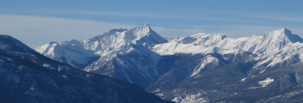
The first description we have of Sinclair Pass comes from George Simpson’s 1841 journey in which he describes the canyon as a, “narrow ravine… literally darkened by almost perpendicular walls of a thousand or fifteen hundred feet in height… the rays of the sun could barely find their way to the depths of this dreary vale so as to render the darkness visible… we were glad to emerge from this horrid gorge, which depressed our spirits even more than it overawed our feelings.”38
Despite this gloomy description of the route as a “horrid gorge”, the track over the pass became much more travelled and popular over time. There are decent records of the pass being used through the 1880s as part of a route that formed a reasonably direct line between the Windermere Valley and the Bow River at Canmore over White Mans Pass.39
The trail in the 1880s was, “rough, crooked, and in places very stony, following in some places the bottom of the valley, in others far up the steep slopes.”40 Nonetheless, it was adequate enough to be used by pack horses.41 It’s very unclear as to when this trail was formed or who made it, although the route was formed by First Nations.
In 1911, construction began on a road connecting Alberta with the Windermere Valley, known as the Banff-Windermere Highway (now Highway 93). This was the first motor road to be built across the Canadian Rocky Mountains to connect Alberta and British Columbia, and it was routed through Sinclair Pass. Construction was delayed by a lack of funds and the First World War, and it was formally opened on 30 June 1923.
Features of Note
A key feature of the route through the pass was, as related in Simpson’s account, what later became known as the Iron Gates, a “huge wall of the most brilliant red rock … far above the forest on either side, narrowing the ravine until it appears impossible for the trail to find its way between the columns of this stupendous gateway.”42

The Iron Gates c1932. Through the Canadian Rockies, Canadian Pacific Railway Company, 1932.
Just to the east of the Iron Gates were a set of pictographs on an under-hang of the canyon wall. Neither of the local First Nations groups, the Ktunaxa or the Shuswap, claim ownership of these pictographs, so their origin is somewhat of a mystery.43 The Encyclopaedia Britannica claims that they indicate human settlement about 11,000 to 12,000 years ago, although they do not cite the study leading to this claim.44 The pictographs were destroyed when the road was widened in 1965.

The pictographs near the iron gates. Windermere Valley Museum and Archives, A242

Looking at pictographs along the Sinclair Canyon road. These pictographs were removed to widen the road. Windermere Valley Museum, a80.
The other feature of note is the small lake at the top of the pass. In 1887 this (then unnamed lake) was described as being,
Later given the name Summit Lake, by 1920 this was changed to Olive Lake.46

Summit Lake at the top of Sinclair Pass (now Olive Lake). The British Columbia Magazine, Vol 8, No 3 (March1912), p193.
Sinclair Canyon
The other iconic feature of Sinclair Pass is Sinclair Canyon itself. Note that early descriptions of “Sinclair Canyon” refer to the entire stretch of road going up past the Iron Gates. Today’s definition is much more specific.
Early photographs of Sinclair Canyon are hard to find, largely as the trail over Sinclair Pass did not go through the canyon itself until after road construction began in 1911. Before then, the route went up and over the canyon rim.
Given the original state of the canyon, it is little surprise that it was not initially used for travel. A surveyor for the original road, Oswald McGuinnes, later recalled that at the time of the survey, “Sinclair Canyon was then just a pin point of light in the sky. The canyon walls rose about 70 feet [21 metres]. There was a 12 foot [3.5 metre] space at the top of the walls and the floor of the canyon was just wide enough to let the stream go tumbling by. They blasted a 12 foot width between the walls so it may surprise you to know that Sinclair Canyon is practically man made.”47

Sinclair Canyon from the west, 1898. Annual Report to the Minister of Mines for the Year Ending 31 December 1898, p 1066.

Sinclair Canyon from the east, before any road development. Windermere Valley Museum, a743.

The “pin point of light.” Note the rock “nose” on the upper right canyon wall, identifying this mass of rock and trees as Sinclair Canyon. Windermere Valley Museum C1464.

Construction begings on the road through Sinclair Canyon. Note the men standing up on the walls, showing just how much material was taken out of the canyon to make a right of way. Windermere Valley Museum, a786.
Even after a road was put through Sinclair Canyon, however, that road initially remained narrow. The canyon was still very much a canyon, with the road snaking tentatively alongside the walls and giving half the width of the canyon floor over to Sinclair Creek. Motorists were hard pressed to ignore this creek as a major feature of the geography.
Contrast this to the road today, which has completely overtaken the canyon as its dominant feature. Unless motorists are paying attention, it is very easy to forget the presence of Sinclair Creek at all. So, too, have the canyon walls continued to be scaled back to control rock fall and excavated further to allow more space for traffic. Just this year, significant work has been undertaken to widen the canyon further as Highway 93 through Kootenay National Park is prepared as an detour route for the Trans Canada Highway, in order for road construction to be done through Kicking Horse Pass. The “pin point of light” has been transformed into a major traffic artery.

A pack train passing through Sinclair Pass shortly before the Banff Windermere Highway was completed in 1923. Although significantly widened, Sinclair Creek remains a dominant feature of the canyon. Windermere Valley Museum a186.

Sinclair Canyon from the hot springs side. Windermere Valley Museum a189.
Other Features
Of course there is one other major feature of note in Sinclair Canyon, and that is the hot springs located near to the Iron Gates. This hot springs was widely known until the 1920s as Sinclair Hot Springs. As this post has already stemmed on for ages, however, we’re going to leave a more thorough description of the hot springs (with plenty more photos) to a pair of posts on Radium Hot Springs, starting next week.
Footnotes
https://dx.doi.org/10.14288/1.0375698
https://dx.doi.org/10.14288/1.0096985
https://dx.doi.org/10.14288/1.0375698
https://hdl.handle.net/2027/hvd.32044082185778
https://hdl.handle.net/2027/hvd.32044082185778
https://dx.doi.org/10.14288/1.0364100
https://hdl.handle.net/2027/hvd.32044082185778
https://doi.org/10.2307/1790499
https://doi.org/10.2307/1790499
https://dx.doi.org/10.14288/1.0356581
https://dx.doi.org/10.14288/1.0096985
https://dx.doi.org/10.14288/1.0356581
https://dx.doi.org/10.14288/1.0356581
https://dx.doi.org/10.14288/1.0356581
https://chroniclingamerica.loc.gov/lccn/sn82014835/1856-05-20/ed-1/seq-3/
https://dx.doi.org/10.14288/1.0375698
https://hdl.handle.net/2027/hvd.32044082185778
https://www.newspapers.com/image/481678601
https://dx.doi.org/10.14288/1.0222211
https://archives.whyte.org/en/permalink/descriptions16042
https://www.britannica.com/place/Kootenay-National-Park
https://dx.doi.org/10.14288/1.0222211
https://www.canadiana.ca/view/oocihm.65299
https://www.newspapers.com/image/480845244
References
http://apps.gov.bc.ca/pub/bcgnws/names/20513.html

Pingback: Roadtrip 2024 – Tokeloshe